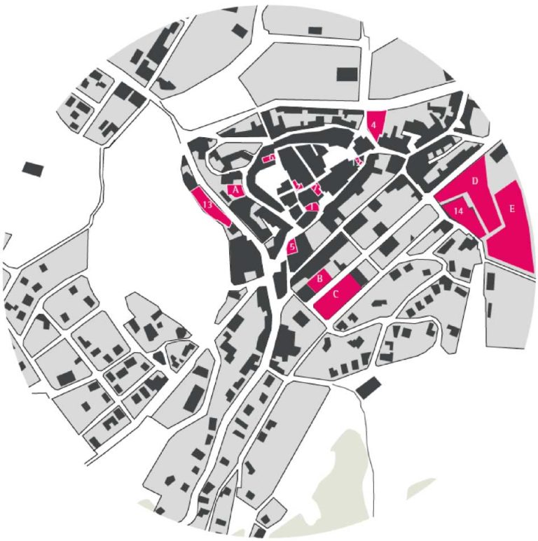
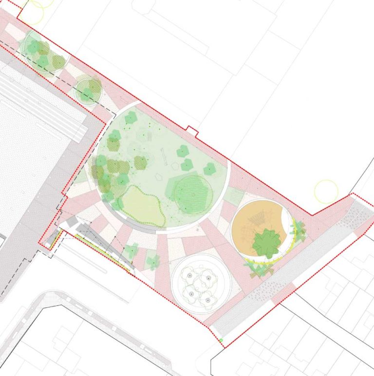
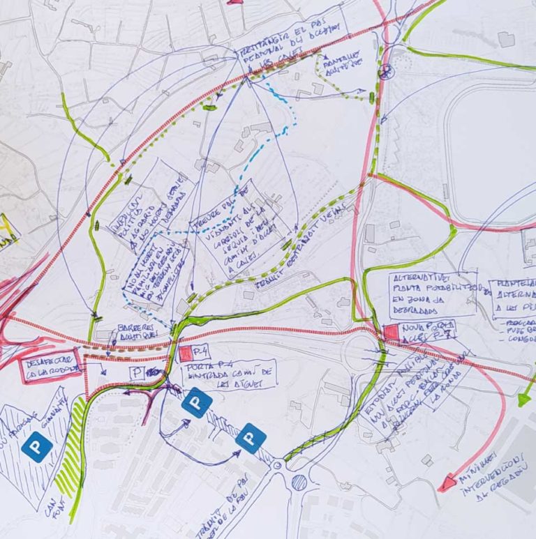
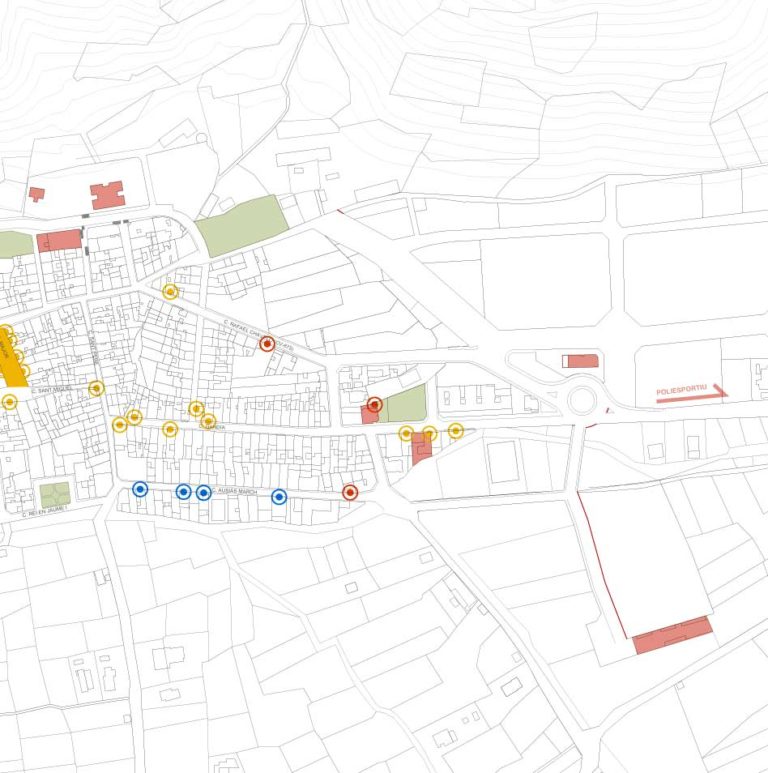
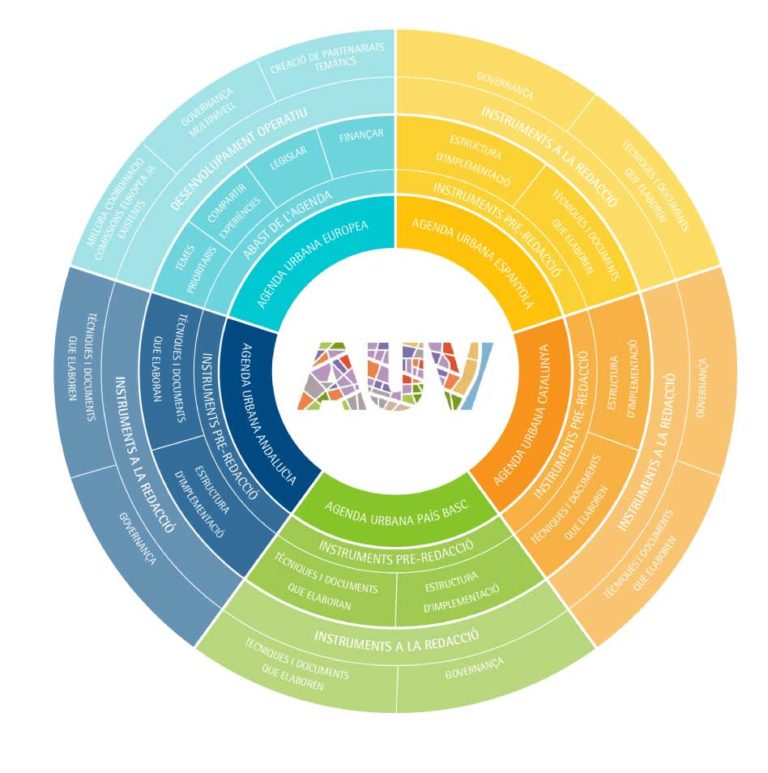
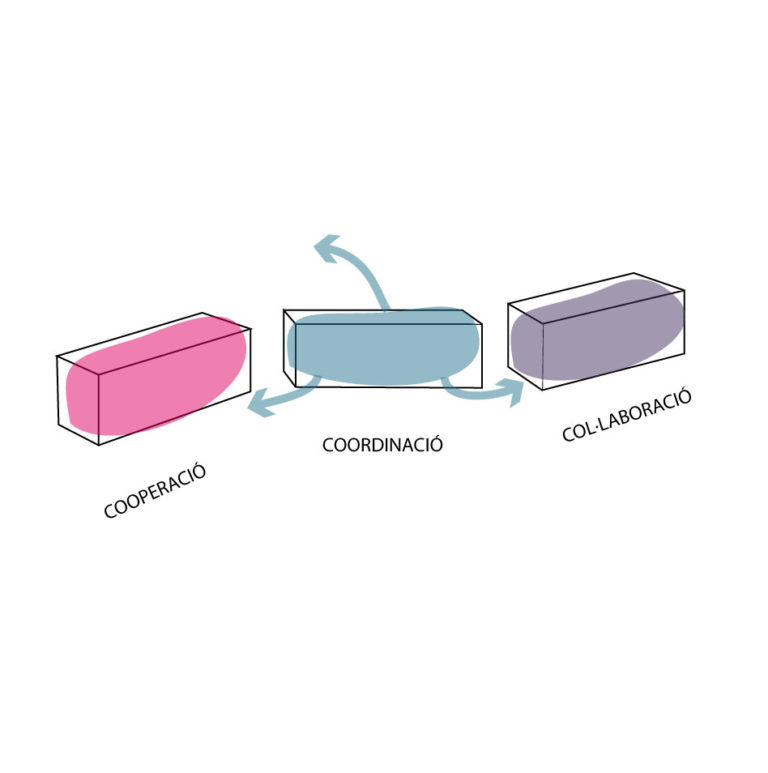
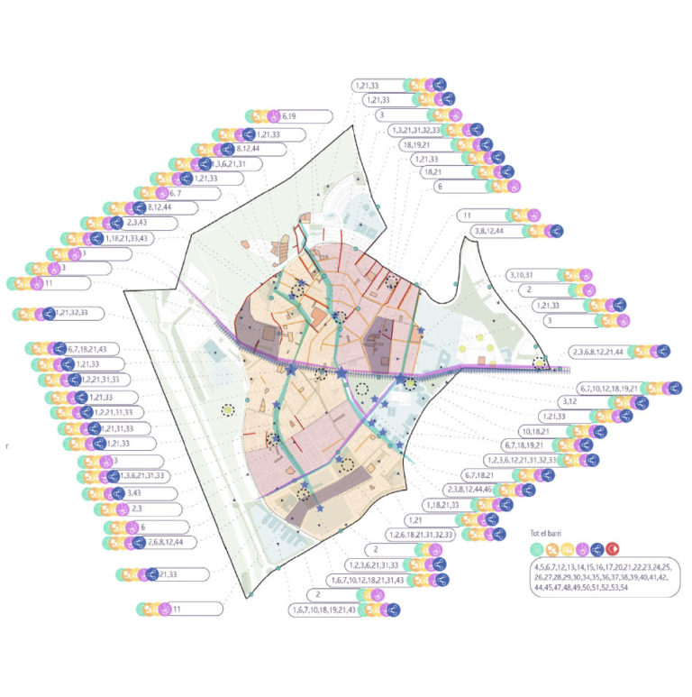
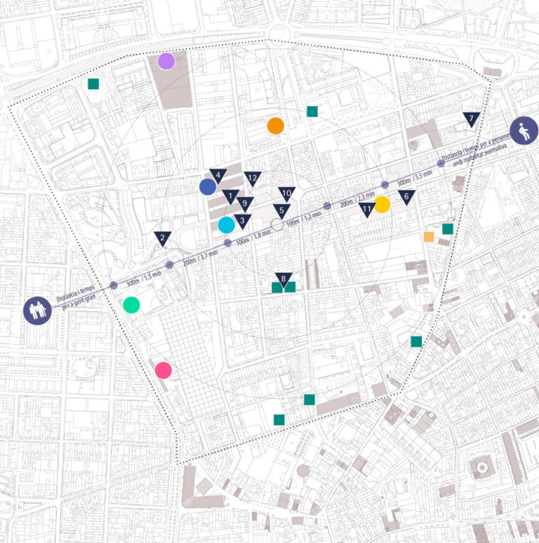
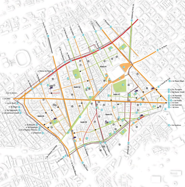
Can Quel, Creation Factory


Can Quel, Creation Factory

The old Can Quel textile factory, an emblematic building deeply rooted in the history of l’Esquirol, is transformed into a public center for socio-cultural creation. A factory of creation.

This municipal building recovers the idea of culture, intervention, and the link with the territory, and is committed to being a platform that contributes to social transformation and sustainable development in Collsacabra, and l’Esquirol in particular.

The Can Quel creation factory, re-exists based on the motto “our future is quality” that is still in the factory, but now is related to culture and community. Likewise, it provides answers to every phase of creative processes and knowledge production -generating individual and/or collective workspaces and making resources available to artists, entities, cultural and social agents, and the public. In addition, it offers educational resources and visibility of projects and activities that reinforce the municipality of Esquirol as a cultural and social pole in Collsacabra.

It is committed to direct collaboration with the different groups to co-manage the equipment, in order to be the ones who shape and make the project grow. 

Can Quel creation factory would be defined from the following three axes:

  • Cross-border culture and education
  • Places of life and social gathering
  • Respect and commitment to the environment and the territory

The participatory process was designed following the PRA methodology (Participatory Research-Action) with the aim of incorporating the maximum diversity of intergenerational perspectives and promoting an inclusive space at l’Esquirol. During the participatory process, the Functional Program, the architectural and urban intervention criteria, the management model, the execution phases, and the management of the “meanwhile” were worked with the local community.

Place

L’Esquirol

[2,181 inhabitants]

Scale

Municipal

Type of project

Urban Strategies

Citizen cooperation

Duration

3 months [2020]

Promoter

Municipality of l’Esquirol

Barcelona Provincial Council


Team

*estel (Konstantina

Chrysostomou, Arnau

Boix, Marc Deu, Alba

Dominguez)


Collaborators

Neighbors of l’Esquirol

Municipal entities

Youth Centre

Technical and political team

of City’s Council

Presentation

Check the presentation at prezi

Socio-territorial analysis in the Study of the Urban Landscape of Montbau


Urban Landscape Study of Montbau

An Urban Landscape study, and especially in a complex area such as Montbau, inevitably approaches the work from various intertwined perspectives in order to reflect the urban reality.

In this case, *estel formed part of a very large team of professionals, and focused on the socio-territorial study, analyzing the human landscape and the everyday dynamics of the neighbourhood, as such as to understand how people relate to the territory as well as to each other.

Through a series of debates with representing stakeholders of the neighborhood in addition to the public realm observation, it was possible to relate amongst others; what was the perception of security in various areas of the neighborhood, which formal and informal spaces were best valued, and why, what urban characteristics define the identity of the neighborhood or in which way the relationship between the city of Barcelona and the mountain of Collserola is perceived.

Place

Barcelona

[1.636.762 habitants]

Scale

Neighborhood

Type of project

Urban Strategies

Citizen cooperation

Duration

8 months [2019]

Promoter

Institut Municipal del

Paisatge Urbà i la Qualitat

de Vida


Team

B2B Arquitectes

*estel (Marc Deu,

Konstantina Chrysostomou,

Arnau Boix, Alba Domínguez)

Irbis

Veclus S.L.

Jordi Bellmunt

Agata Buscemi

Fàtima López

Montserrat Mercadé


Collaborators

Neighbors of Montbau

Informe

Read the full report at

BCNROC Barcelona

Transforming Ca n’Altimira into a space for community innovation


Transforming Ca n’Altimira into a space for community innovation

How can we define new uses for a symbolic building respecting its history and its importance for citizens? How can we transform it into a pedagogical space where the social fabric is empowered, allowing us to speak for a new model of co-management of the municipal facilities?

The process of citizen participation for the definition of the new uses and the management model of the old municipal library of Cerdanyola del Vallès was an innovative and intergenerational project. During the process, were carried out, on the one hand, participatory actions (talks, table games, walks, 3d printing, …) and on the other the communication plan of the process (informative actions on public space, communicative image, exhibition, and installations regarding Ca n’Altimira’s history, and its participative process). 

The involvement of citizens during the collaborative analysis and diagnosis helped to detect the needs regarding spaces and activities and to structure a network of municipal facilities that could host them. Moreover, this co-production between administration and citizens helped to build a common story regarding the Functional Plan of  Ca n’Altimira. This Plan includes a program of uses (artistic, technological, social), the equipment’s management model, and the architectural criteria for the transformation and the proposed distribution of uses.

Place

Cerdanyola del Vallès

[57,740 inhabitants]

Scale

Public space

Type of project

Urban Strategies

Citizen cooperation

Duration

13 months [2016-2017]

Promoter

Barcelona Provincial Council

Municipality of Cerdanyola de

Vallès


Team

*estel (Arnau Boix,

Konstantina Chrysostomou,

Marc Deu, Soledad Viteri)

MonoD estudio

Urbanins


Collaborators

Non-associated citizens,

Collectives,

Entities and Associations

Presentation

Check the presentation at prezi


Study

Read the full report at issuu


Press

Read more about the project

in the digital newspaper

 Cerdanyola al dia

Urban strategies for San Francisco neighborhood​


Urban strategies for San Francisco neighborhood

The neighborhood of San Francisco, in the municipality of Villena, is a residential area developed during the 60s by the Francoist Ministry of Housing. Over the years, it has been subjected to a process of constant degradation that has ended to generate a setting with significant deficits both socially and architecturally, subjecting the local population to high levels of social vulnerability.

*estel elaborated a document of urban strategies, which is presented together with the socio-urban diagnostic document prepared by monoDestudio team. Both documents aim to establish the main axes of an intervention that allow reversing these dynamics.

A wide variety of parameters are analysed, ranging from the urban classification defined in the current PGOU (town plan), the conditions of the buildings, the property regime, to the main characteristics that define the neighbourhood’s everyday life.

Various areas of action are defined as taking advantage of the potentials and opportunities detected in the neighborhood,  These transformation actions act as change generators and help to improve residents life quality.

Place

Villena

[33,983 inhabitants]

Scale

Neighborhood

Type of project

Urban Strategies

Duration

6 months [2018 – 2019]

Promoter

Municipality of Villena


Team

monodDestudio


*estel (Arnau Boix i Pla,

Alba Domínguez Ferrer,

Marc Deu Ferrer,

Konstantina Chrysostomou)


TESEU


Collaborators

Neighbors of Villena

From an abandoned football field to a new community park


Turning the football field of Montornes Nord into a community park

The renewal and revitalization of the abandoned football field of Montornes Nord, a place full of memories for the neighbours, aims to implement a sustainable urban strategy and bring new life to a degraded urban area, according to the needs and ideas of its residents. The project focuses on integrated solutions to improve environmental, transport, and economic mismatches with the surroundings, reduce issues of social exclusion and segregation, to strengthen social cohesion. It enables a comprehensive, participatory, and integrated attitude of all stakeholders, bringing together the expertise and experience of the actors involved. It supports the economical, environmental, and social use of public land and the transition towards the rational use of energy while encouraging cooperation between residents and the municipality. 

For this project, we have developed various tools for gathering information about the residents’ needs, as well as various methods of working with the residents through project-based learning. We have given them space for intergenerational dialogue and exchange of memories and experiences, a community walk to the old football field, playful activities, and games for the incorporation of youth and children’s perspectives to the project and informative sessions with experts regarding the social economy and sports. With these activities, we have established close cooperation between residents and municipal authorities, public services, and other important actors in the neighborhood and the municipality.

The result of this process is a preliminary masterplan for a multifunctional park that synthesizes the experience collected from the participants and suggestions of various polycentric development strategies to the municipality (social, economic, environmental, strategies of spatial planning, mobility, and infrastructure, etc.). 

Regarding the participatory approach, residents of different age groups participated in the planning and assumed active roles and responsibilities for the development of the masterplan and the activation of the place. By engaging every generation in each phase of the process -not only during the co-design but also during the execution of the project and the activation of the park- already increases the sense of connectedness, leading to less vandalism of this public space. Various strategies have been proposed to make the space more attractive and used more frequently by the residents in the meantime increasing the pride and giving a positive attitude toward an improved quality of life in the neighborhood. 

* Project awarded with the AJAC AWARD in the category of Participatory Processes, during the AJAC XII AWARDS  for the projects carried out during the biennium 2018-2020.

Place

Montornès del Vallès

[16,393 inhabitants]

Scale

Public space

Type of project

Urban Strategies

Citizen cooperation

Duration

7 months [2018-2019]

Promoters

Municipality of Montornès

del Vallès


Team

*estel (Konstantina

Chrysostomou, Alba

Domínguez, Marc Deu)


EKONA


Collaborators

Neighbors of Montornès

Nord,

Collectives, Entities and

Associations (environment,

local economy, health and

sports, community),

La Marinada School,

El Satèl·lit Youth Centre,

La Peixera

Presentation

Check the presentation at prezi


Press

Read more about the project at

Som Montornès


Award

Check the video of the AJAC XII

awards ceremony on youtube


Restructuring the Plaça Joan Ragué i Camps


Restructuring the Plaça Joan Ragué i Camps

The restructure of the Joan Rague I Camps square and its surroundings implemented a sustainable urban strategy that prioritizes people over cars and improved the quality of the public space, according to the needs and ideas of its residents. The project focused on integrated solutions to reduce mobility problems, issues of accessibility, and weak public realm with the aim of strengthening the city’s identity and social cohesion. It enabled a comprehensive, participatory and integrated attitude of citizens, politicians, and administration, bringing together the expertise and experience of the actors involved. 

The project supports the implementation of sustainable urban strategies, offering citizens and relevant stakeholders a comprehensive, integrated, innovative, and participatory approach to identifying the problems, challenges, and opportunities with the goal of finding appropriate solutions for the renewal and revitalization of urban space in line with the values and principles of a sustainable urban life: improving the quality of life for citizens, activating social life, stimulating economic growth and taking effective measures for reducing vehicle’s velocity in the city’s center. 

From the earliest stages of the project, intergeneration participation was essential. It involved interviews with entities, diagnosis walks, and in-situ activities for setting criteria and testing actions,  together with inhabitants. The process not only helped to rethink and respect the environment and public space, introducing actions that guarantee universal accessibility, prioritization of people over cars, and healthy social life, but it also set in motion a participatory dynamic, a future of dialogue and discussion to a participatory and responsible community.

Place

Gualba

[1,481 inhabitants]

Scale

Public space

Type of project

Urban Strategies

Citizen cooperation

Duration

6 months [2018-2019]

Promoters

Municipality of Gualba


Team

*estel (Arnau Boix, Konstantina

Chrysostomou, Alba Domínguez,

Marc Deu)


Collaborators

Residents of Gualba,

Local entities (education,

economy, commerce, sports,

cultural, social)

Presentation

Check the presentation at prezi

Press

Read more about the project at 

Gualba Municipal Bulletin

Qualitative analysis of Sants-Hostafrancs public realm


Study of Sants-Hostafrancs public realm

For the redaction of Uses Plan for the Sants-Hostafrancs triangle, *estel has executed a complementary territorial and social investigation in order to give arguments for the decision-making. This research is part of the “Uses Plan Participatory process and Commercial Dynamization Plan” carried out by MonoDestudio.

The study is limited to an area of 33 hectares that includes part of the Sants and Hostafrancs neighborhoods of Barcelona. Within this area, however, there are places of variable scales: from small neighborhood squares to the city’s public spaces. All of them accommodate both foreseeable and unforeseen activities, completing the whole range of events in the urban public sphere.

For the realization of the study, an observation has been carried out for two days, one during a weekday and another one at the weekend in 5 different moments of the day (morning, midday, afternoon, night, midnight). That methodology aimed to unveil the patterns of the activities that are allocated to the study area in order to understand and explain the fundamental information regarding who is doing what and where within some parameters of established activities. 

Thus, amongst others, it has been identified and studied the network of public spaces and its anomalies, pedestrian mobility, activities that take place, and safety perception. To better understand the main public spaces and their realm, a comparison between them has been done regarding social interaction, diversity of activities, amount of people, materiality, and dynamics between private and public space.

Place

Barcelona

[1,620,343 inhabitants]

Scale

District

Type of project

Urban Strategies

Citizen Cooperation

Duration

3 months[2016]

Promoters

Municipality of Barcelona

Sants District


Team

TESEU


*estel, MonoD estudio


Collaborators

Entities and neighbours of

Sants district 

Study

Read the full report at  issuu

Transforming the old factory SATI into a community hub


Transforming the old factory SATI into a community hub

This project for the re-use of the abandoned industrial building SATI, overseen by the Barcelona Provincial Council and the Alpens town hall, encouraged participatory methodologies and social integration. The project is related to a building that has been part of the life of Alpens for more than 40 years. This container of experiences has become part of the landscape and the memories of the citizens who have worked there. The purpose was to rethink this place, set the criteria and define the new uses and management model.  

This project explored co-housing scenarios for the elderly and artists, co-management of green spaces and a shared kitchen, adaptation of the traditional Catalan “era” (threshing floor) into the present context, and creation of co-working and learning spaces for everyone. From the earliest stages of the project, intergenerational participation was essential. It involved workshops with children, interviews with entities and building games, and defining spaces together with inhabitants. 

This participatory planning project is an example of an integrated approach to problem-solving regarding the adaptive reuse of industrial buildings in order to provide economic, cultural, and social benefits to the community and regenerate the area sustainably. Not only it helped to rethink and respect the environment and public space, but it also set in motion a participatory dynamic, a future of dialogue and discussion to an even more participatory and responsible community. 

Place

Alpens

[273 inhabitants]

Scale

Public space

Type of project

Urban Strategies

Citizen cooperation

Duration

5 months [2018]

Promoters

Barcelona Provincial Council

Alpens City Council


Team

*estel (Arnau Boix, Konstantina

Chrysostomou, Alba Domínguez,

Marc Deu)


MonoD estudio


Collaborators

Residents of Alpens, 

Educational community, 

Local entities (sports, cultural,

social)

Presentation

Check the project at prezi

Confluence in Valencia’s Central Market


Confluence in Valencia's Central Market

The proposal Confluència was the winner of the competition organized by the Generalitat Valenciana in order to remodel Bruges square and other public spaces around the Central Market of the city of Valencia. The project, led by the architects Elisabet Quintana and Blanca Peñín, opted for a transdisciplinary and participatory approach, with the firm intention of facilitating the creation of a space of coexistence around this commercial node, the Central Market, which is a historical symbol and a landmark for the inhabitants and visitors of Valencia.

The conception of public space as a natural extension of the Market itself, and vice versa, respects and reinforces the social, cultural, and commercial dynamics of the urban environment. The final proposal addresses the neighborhoods’ socio-territorial circumstances not only through urban design, but also through social strategies to visualize the different human realities that enclose an important social building such as a public market. These strategies range from proposals for neighborhood programming to public spaces that strengthen human connectivity with the Velluters neighborhood, to measures for reversing the gentrification process in Valencia in general, and the Ciutat Vella district in particular.

The  Confluència’s team transdisciplinary context has allowed the incorporation of diverse perspectives throughout the process of reflection, proposal, and writing, which include considerations on governance, citizen participation, and gender.

The redevelopment is expected to begin in 2020.

Place

Valencia

[794 288 inhabitants]

Scale of the project

Municipal

Public space

Tipus de projecte

Estratègies urbanes

Disseny d’espai públic

Duration

6 months [2018]

Promoter

Generalitat Valenciana,

Municipality of Valencia


Team

UTE Quintana-Peñín  (Elisabet

Quintana i Blanca Peñín)

Equip transdisciplinar: Peñín

arquitectes, Espinàs i Tarrassó,

*estel, monoDestudio, Inés

Novella, Planifica Urbanismo y

Gestión, Enrique Giménez, Joan

Seguí, María Pedro Ferrer


Collaborators

Local entities and associations

Press

Watch the video of the project

here here

Read more about the project at

diari

¡Pónle Guinda!


¡Pónle Guinda!

¡Pónle Guinda! is a process of citizen and administrative cooperation in order to carry out a participatory diagnosis and agree on proposals for the transformation of the public space in an area of Guindalera neighborhood (Madrid), popularly known as Guindalera Vieja. The work process in Guindalera Vieja comprised three distinct phases: start-up, participation, and preliminary drafting phase.

During the first one, group meetings and interviews were held with municipal technicians and political representatives of the Madrid City Council (Salamanca District), as well as with a representation of the neighborhood’s associative network. 

During the second phase was held the urban and social analysis, fieldwork, and observation mapping of the public space along with the open workshops for every neighbour who wanted to participate. That phase closed with conclusion elaboration and its subsequent communication to all the people participating in these workshops. 

Finally, it was elaborated the drafting of the prioritized projects from the previous phases: the proposal of a sustainable mobility model for the neighbourhood; the establishment of a “toolbox” with general criteria for the design of Guindalera`s public spaces; and the drafting of two preliminary projects, corresponding to the Béjar street, and to the May 28 square and its surroundings. 

The decision-making was based on the experts’ knowledge arising from the fields of sociology, urbanism, and architecture as well as from the neighbours’ shared experiences who have been implicated in the participatory process. This process marked the guidelines for the subsequent redevelopment work of the neighbourhood.

Place

Madrid

[3,223,334 inhabitants]

Scale

Neighborhood

Type of project

Urban Strategies

Citizen cooperation

Public space design

Duration

10 months [2017]

Promoter

Municipality of Madrid,

Salamanca District


Team

*estel (Arnau Boix, Mireia Peris,

Konstantina Chysostomou,

Soledad Viteri)


MonoD estudio, Urbanins,

Inés Novella


Collaborators

Neighbors and neighborhood

organizations in Guindalera

Presentation

Check the presentation at Prezi

Press

Read more about the project at 

DSalamanca and DSalamanca